Volcano in Russia’s Far East Erupts After 450 Years
Key Facts:
-
Name of Volcano: Krasheninnikov
-
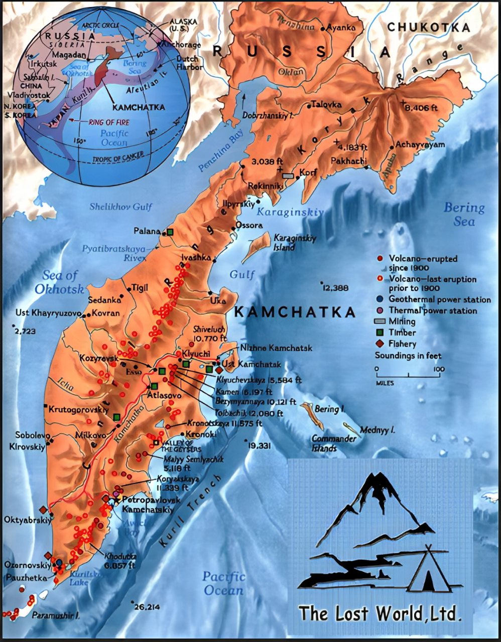
Location: Kamchatka Peninsula, Far Eastern Russia
-
Last Eruption: 1550 AD — first eruption in 450 years
-
Recent Eruption: August 2025
-
Plume Height: Reached 6,000 meters (6 km) into the atmosphere
-
Event Context: Eruption followed one of the strongest earthquakes on record in the region, indicating tectonic disturbances

Geological Significance:
-
Kamchatka Peninsula lies on the Pacific Ring of Fire, known for intense volcanic and seismic activity.
-
The Krasheninnikov volcano is part of a complex volcanic structure involving two stratovolcanoes.
-
Long dormancy makes eruptions more unpredictable and potentially hazardous.
Disaster Implications:
-
Ash clouds at 6,000 m can affect air travel, human health, and climate (short-term cooling).
-
Earthquake-volcano connection suggests plate movement along convergent boundaries.
-
Highlights the need for monitoring dormant volcanoes, especially near populated or strategic zones.
Tectonics of the Kamchatka Peninsula
Location & Geology
-
Kamchatka Peninsula: 1,250 km long, located in Far Eastern Russia
-
Part of the Pacific Ring of Fire
-
One of the most tectonically active regions on Earth
Kamchatka Peninsula: 1,250 km long, located in Far Eastern Russia
Part of the Pacific Ring of Fire
One of the most tectonically active regions on Earth
Tectonic Setting
-
Situated at a triple plate junction:
-
Pacific Plate
-
North American Plate
-
Eurasian Plate
-
Includes the Okhotsk Block (sometimes called the Okhotsk Plate)
-
Nearby geological blocks:
-
Bering Block (north of Aleutians)
-
Possible influence of Emperor Seamount Chain subduction
Situated at a triple plate junction:
-
Pacific Plate
-
North American Plate
-
Eurasian Plate
Includes the Okhotsk Block (sometimes called the Okhotsk Plate)
Nearby geological blocks:
-
Bering Block (north of Aleutians)
-
Possible influence of Emperor Seamount Chain subduction
Okhotsk Plate (Block)
-
A microplate or remnant of the ancient Kula Plate
-
Western Boundary: Subducting under Eurasian Plate (inactive)
-
Eastern Boundary: Kuril–Kamchatka Trench (active subduction, volcanism)
-
Southern Boundary: Unclear; debated between northern Hokkaido and central Japan
-
Northern Boundary: Ulakhan Fault (transform fault with westward motion)

A microplate or remnant of the ancient Kula Plate
Western Boundary: Subducting under Eurasian Plate (inactive)
Eastern Boundary: Kuril–Kamchatka Trench (active subduction, volcanism)
Southern Boundary: Unclear; debated between northern Hokkaido and central Japan
Northern Boundary: Ulakhan Fault (transform fault with westward motion)
Volcanism
-
Driven by subduction of the Pacific Plate
-
Eruptions are andesitic, with many caldera-forming events
-
160 volcanoes, ~29 are active (monitored by KVERT)
-
Most recent eruptions occur east of a central fault in Kamchatka
Driven by subduction of the Pacific Plate
Eruptions are andesitic, with many caldera-forming events
160 volcanoes, ~29 are active (monitored by KVERT)
Most recent eruptions occur east of a central fault in Kamchatka
Volcanic Features
-
Double volcanic arcs:
-
Western arc: Mostly inactive
-
Eastern arc: Active; extends southward toward Kuril Islands and Japan
-
Major volcanic zones:
-
Bezymianny Volcanic Complex (in Central Kamchatka Depression)
-
Shiveluch (northernmost active volcano)
-
Kliuchevskoi Group: One of the most active clusters
Double volcanic arcs:
-
Western arc: Mostly inactive
-
Eastern arc: Active; extends southward toward Kuril Islands and Japan
Major volcanic zones:
-
Bezymianny Volcanic Complex (in Central Kamchatka Depression)
-
Shiveluch (northernmost active volcano)
Kliuchevskoi Group: One of the most active clusters
Kamchatka–Aleutian Triple Junction
-
Area where Pacific, North American, and Okhotsk Plates meet
-
Located off east-central Kamchatka, forms a zone of crustal weakness
-
Allows magma to reach surface easily
-
Parallels the Aleutian Trench (west end is more of a transform fault)

Area where Pacific, North American, and Okhotsk Plates meet
Located off east-central Kamchatka, forms a zone of crustal weakness
Allows magma to reach surface easily
Parallels the Aleutian Trench (west end is more of a transform fault)
Emperor Seamount Chain
-
Ancient hotspot-generated seamounts now subducting under Kamchatka
-
Brings hydrated oceanic material, enhancing magma productivity
Ancient hotspot-generated seamounts now subducting under Kamchatka
Brings hydrated oceanic material, enhancing magma productivity
Kuril–Kamchatka Trench
-
Deep ocean trench (up to 10 km)
-
Extends from Kamchatka to northern Japan (Hokkaido)
-
Hosts volcanic island arc (Kuril Islands)
Deep ocean trench (up to 10 km)
Extends from Kamchatka to northern Japan (Hokkaido)
Hosts volcanic island arc (Kuril Islands)