Star-based Navigation in Deep Space
Background
-
Problem: Navigation in deep space is difficult; no GPS exists, and Earth-based tracking (Deep Space Network – DSN) becomes weaker with distance.
-
Context: NASA’s New Horizons spacecraft (launched 2006, Pluto flyby 2015, Kuiper Belt mission, now beyond 60x Earth-Sun distance) provided an opportunity to test new navigation methods.
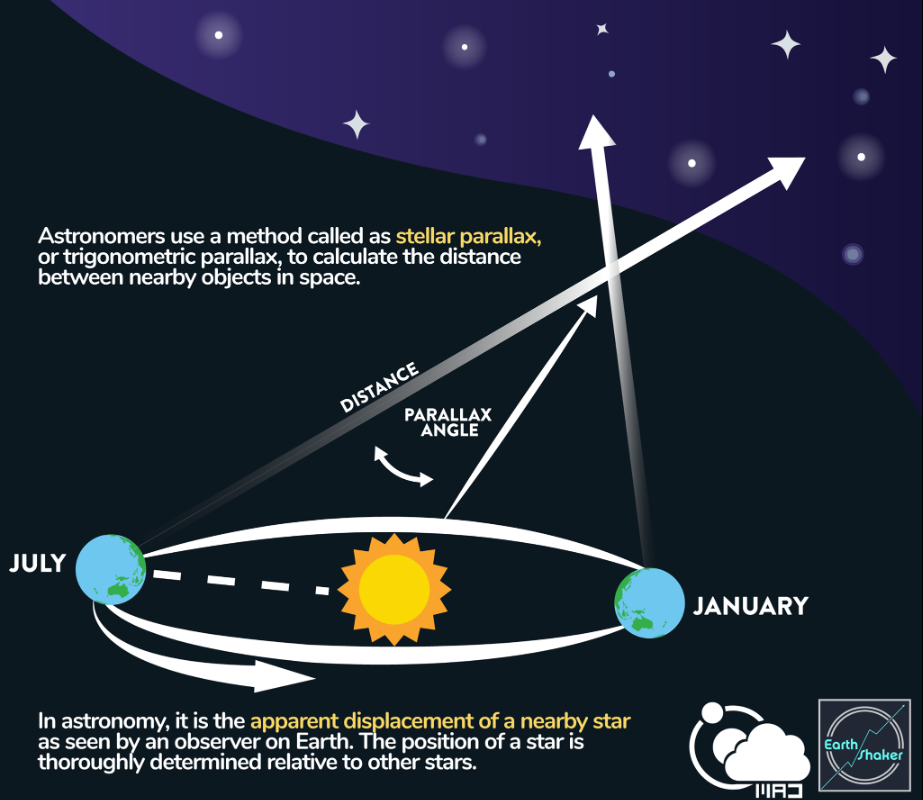
- Parallax is the apparent change in the position of an object when viewed from different angles. Imagine holding your finger out and closing one eye, then the other; your finger seems to jump.
- Astronomers use the same principle to measure the distance to stars. They take a photo of a star, wait six months for Earth to move to the opposite side of its orbit, and take another photo. The star will appear to shift slightly against the background of more distant objects.
- The tiny angular distance the star appears to shift is its parallax angle, usually measured in arcseconds.
-
Stellar parallax is apparent shift in position of a star when viewed from two different vantage points.
-
Candle seen with left vs. right eye shifts relative to background.
-
The shift is called parallax angle, related to distance.

The Study (Astronomical Journal, June 2025)
-
Stars used: Proxima Centauri (4.2 light years) and Wolf 359 (7.9 light years).
-
Observations: From Earth and New Horizons (7 billion km apart on April 23, 2020).
-
Findings:
-
Parallax measured: Proxima – 32.4 arcseconds; Wolf 359 – 15.7 arcseconds.
-
Calculated distance: 46.89 AU, matching DSN radio-tracking (47.11 AU).
-
-
ESA’s Gaia spacecraft data (3D stellar positions).
-
Only a camera, spacecraft computer, and stellar catalogue.
Advantages of Star-based Navigation
-
Provides self-sufficiency in deep space.
-
No dependence on Earth’s radio signals.
-
Simple and low-cost – no special equipment needed.
-
Potentially useful for interstellar missions where Earth-based tracking is impossible.
Comparison with Other Methods
-
Stellar Astrometric Navigation: Uses angular separation between stars + relativity corrections.
-
Pulsar Navigation: Uses spinning neutron stars; more accurate but needs prior position estimate.
-
New method = simpler version, but less accurate.
Significance for India & ISRO
-
As India expands missions (Aditya-L1, Chandrayaan series, interplanetary missions), autonomous navigation reduces reliance on ground-based tracking.
-
Supports Atmanirbhar Bharat in space technology.
-
Aligns with India’s participation in global astronomical projects (e.g., SKA, upcoming deep-space networks).
Limitations
-
Accuracy still limited with current spacecraft cameras.
-
Not immediately applicable for active missions like New Horizons.
-
Needs technological improvements before becoming operational.