Sir Creek Issue & Recent Developments
Context
On Vijayadashami (2 Oct 2025), Defence Minister Rajnath Singh performed Shastra Puja at Bhuj sector (Gujarat).
He warned Pakistan against aggression in Sir Creek, stressing that “a route to Karachi passes through Sir Creek” and aggression would receive a “resounding response changing history and geography.”
Sir Creek Dispute: A Cartographic & Maritime Dilemma
Introduction
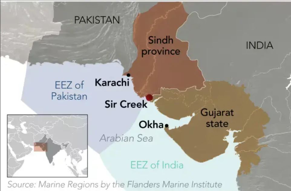
Sir Creek (local name: Baan Ganga) is a 96 km tidal estuary in the marshes of the Rann of Kutch, where the Arabian Sea merges with land.
It is not a true river but a fluctuating tidal channel.
Lies between Gujarat (India) and Sindh (Pakistan).
A joint survey (2007) noted the creek had shifted 1.5 km eastwards, complicating the dispute.
Dispute arose because partition left this border undemarcated.

Background
Gujarat coast: Gulf of Kutch and Gulf of Cambay.
Pakistan’s Sindh coast adjoins Gujarat, but no bilateral maritime boundary agreements exist.
Fishing laws absent; both sides follow national maritime zone acts, but neither fully aligns with UNCLOS.
Dispute originated between Rao of Kutch and Chief Commissioner of Sindh (British India) over boundary interpretations.
The 1914 Bombay Resolution
The Bombay Government survey (1914) issued a verdict with contradictory clauses:
Paragraph 9: Boundary lies east of the creek → Creek belongs to Sindh (Pakistan’s claim).
Paragraph 10: Creek is navigable most of the year → Boundary lies mid-channel, dividing it (India’s claim, based on international law of navigable waterways).
Cartographic Dilemma
1925 Map: A “Green Riband” line drawn east of the creek.
Pakistan: It marks Sindh–Kutch boundary, so creek belongs to Sindh.
India: It was only a cartographic convention, not a territorial boundary.
Till 1954, border was fluid with free movement; afterwards, rigid stances hardened.
By 1968, both sides presented competing historical claims.
Importance of Sir Creek
Fishing grounds – Among the largest in Asia; sustains local fishermen.
Energy resources – Rich in hydrocarbons & shale gas.
Maritime claims – Determines EEZ boundaries in the Arabian Sea.
Strategic value – Limited military utility, but important for coastal security & surveillance.
India’s & Pakistan’s Claims
India:
Cites Para 10 of 1914 verdict → boundary mid-channel.
Argues Kutch was a well-defined princely state under Mughals and British.
Claims tribunal (1968) awarded 90% of Rann of Kutch to India.
Pakistan:
Cites Para 9 of 1914 verdict → boundary east of creek.
Claims Kutch never had independent existence; Sindh rulers historically dominated region.
Argues 1925 “green line” confirms boundary.