Cyclones – Formation, Classification & Forecasting
Definition
Cyclones are intense low-pressure systems characterized by strong winds, heavy rainfall, and storm surges.
Known as:
Hurricanes – Atlantic & Eastern Pacific
Typhoons – Western Pacific
Cyclones – Indian Ocean
Formation Conditions (Favourable Factors)
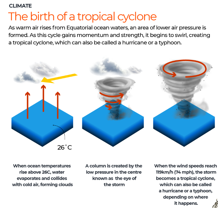
Warm Sea Surface Temperature (SST) – above 26.5°C up to 50 m depth.
Moist air – rising air releases latent heat → enhances convection.
Atmospheric instability – continuous upward movement of warm, moist air.
Coriolis Force – sufficient deflection due to Earth’s rotation to induce rotation.
Absent near equator → cyclones rarely form within 5° latitude of the equator.
Low Vertical Wind Shear – minimal difference in wind speed/direction between lower and upper atmosphere.
Pre-existing disturbance – area of low pressure or thunderstorms to trigger formation.

Structure of a Tropical Cyclone
Eye – calm, clear, low-pressure centre.
Eyewall – ring of towering thunderstorms with strongest winds & heaviest rainfall.
Spiral rainbands – bands of clouds and rain spiraling outward.
Air circulation – inflow at surface, outflow aloft.

Classification (India Meteorological Department - IMD)
Category | Wind Speed (km/h) |
Depression | 31–49 |
Deep Depression | 50–61 |
Cyclonic Storm | 62–88 |
Severe Cyclonic Storm | 89–117 |
Very Severe Cyclonic Storm | 118–165 |
Extremely Severe Cyclonic Storm | 166–221 |
Super Cyclonic Storm | >222 |
Energy Source
Draws energy from latent heat of condensation when moist air rises and condenses.
As long as it stays over warm ocean water, it can intensify.
Observation & Monitoring
Techniques used:
Satellites:
Infrared imagery – measures cloud-top temperatures to estimate intensity.
Visible & microwave sensors – reveal internal structure and rainfall.
Aircraft reconnaissance (Hurricane Hunters):
Dropsondes measure wind, pressure, humidity, and temperature.
Ocean buoys: Continuous data on SST, pressure, and wind.
Ground-based radar – track landfall and rainfall patterns.
Forecasting
Uses Numerical Weather Prediction (NWP) models to simulate atmospheric and oceanic conditions.
Forecast uncertainty: arises due to small errors in initial data and model limitations.
Forecast accuracy: 3–5 days in advance with reasonable precision.
Improved through:
Satellite remote sensing
Data assimilation
Computational advancements
Regional Naming & Monitoring Agencies
North Indian Ocean: India Meteorological Department (IMD) – official Regional Specialized Meteorological Centre (RSMC) for cyclone warnings.
Other regions:
NOAA (U.S.) for Atlantic
JMA (Japan) for Western Pacific
Key Concepts
Coriolis Effect: Causes air to spiral around the low-pressure centre (right in Northern Hemisphere, left in Southern).
Latent Heat: Main driver of energy.
Vertical Wind Shear: High shear weakens storms by disrupting vertical structure.
Recent Improvements
Real-time data from INSAT-3D/3DR satellites and Oceansat enhance early warning.
IMD’s early warning systems now include probabilistic track forecasts and impact-based warnings.
Prelims Practice MCQ
Q. Consider the following conditions necessary for the formation of a tropical cyclone:
Warm sea surface temperature of at least 26.5°C extending to a considerable depth.
High vertical wind shear between lower and upper atmospheric levels.
Presence of Coriolis force to initiate cyclonic rotation.
Location within 5° latitude from the equator.
Which of the statements given above are correct?
A. 1 and 3 only
B. 1, 2 and 3
C. 2 and 4 only
D. 1, 3 and 4
✅ Answer: A
Explanation:
Warm SST (>26.5°C) is essential to provide latent heat energy. ✔️
Coriolis force is needed to induce rotation, which is absent near the equator. ✔️
High wind shear disrupts cyclone formation ❌
Cyclones rarely form within 5° of the equator ❌
Q. With reference to tropical cyclones, consider the following statements:
The eye of a cyclone is a region of calm winds and clear skies.
The strongest winds and heaviest rainfall occur around the eyewall.
In the Southern Hemisphere, the winds circulate clockwise around the eye.
Which of the statements given above are correct?
A. 1 and 2 only
B. 2 and 3 only
C. 1 and 3 only
D. 1, 2 and 3
✅ Answer: D
Explanation:
The eye is calm and cloud-free. ✔️
The eyewall has the most intense winds and rainfall. ✔️
Due to Coriolis deflection, rotation is clockwise in the Southern Hemisphere and anticlockwise in the Northern. ✔️
Q. With reference to cyclone observation and forecasting, consider the following pairs:
Instrument / Technology | Function |
1. Dropsonde | Measures pressure and humidity inside cyclone |
2. Infrared imagery | Estimates cloud-top temperatures and storm intensity |
3. Microwave sensors | Detect rainfall structure and internal dynamics |
Which of the pairs given above are correctly matched?
A. 1 and 2 only
B. 1 and 3 only
C. 2 and 3 only
D. 1, 2 and 3
✅ Answer: D
Explanation:
All three pairs are correctly matched — these technologies are used in modern cyclone monitoring, especially where aircraft reconnaissance is limited (like in the Indian Ocean).